Back مقاطعة كولومبيا (أركنساس) Arabic Columbia County, Arkansas BAR Колумбия (окръг, Арканзас) Bulgarian কলম্বিয়া কাউন্টি, আরকান্সাস BPY Columbia Gông (Arkansas) CDO Колумбия (гуо, Арканзас) CE Columbia County (kondado sa Tinipong Bansa, Arkansas) CEB Columbia County, Arkansas Welsh Columbia County (Arkansas) German Κομητεία Κολούμπια (Άρκανσο) Greek
33°14′28″N 93°13′06″W / 33.24111°N 93.21833°W
Columbia County | |
|---|---|
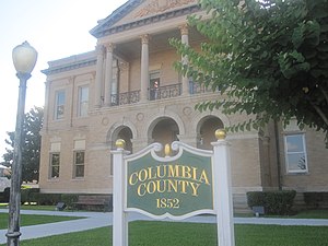
 Columbia County Courthouse in Magnolia | |
 Location within the U.S. state of Arkansas | |
 Arkansas's location within the U.S. | |
| Coordinates: 33°14′28″N 93°13′06″W / 33.241111111111°N 93.218333333333°W | |
| Country | |
| State | |
| Founded | December 17, 1852 |
| Named for | Christopher Columbus |
| Seat | Magnolia |
| Largest city | Magnolia |
| Area | |
| • Total | 767 sq mi (1,990 km2) |
| • Land | 766 sq mi (1,980 km2) |
| • Water | 0.7 sq mi (2 km2) 0.1% |
| Population (2020) | |
| • Total | 22,801 |
| • Density | 30/sq mi (11/km2) |
| Time zone | UTC−6 (Central) |
| • Summer (DST) | UTC−5 (CDT) |
| Congressional district | 4th |
| Website | www |
Columbia County is a county located in the U.S. state of Arkansas. As of the 2020 census, the population was 22,801.[1] The county seat is Magnolia.[2] The county was formed on December 17, 1852, and was named for Christopher Columbus. The Magnolia, AR Micropolitan Statistical Area includes all of Columbia County.
In 2014, voters overturned a 71-year-old prohibition against the sale of alcoholic beverages in the county.[3]
- ^ "Census - Geography Profile: Columbia County, Arkansas". United States Census Bureau. Retrieved January 19, 2023.
- ^ "Find a County". National Association of Counties. Archived from the original on May 31, 2011. Retrieved June 7, 2011.
- ^ "Election results: Columbia County goes wet, Vann wins Magnolia mayor's race, Blair new county treasurer". Magnolia Reporter – Magnolia, Arkansas News.
© MMXXIII Rich X Search. We shall prevail. All rights reserved. Rich X Search